Solaria (for Parts One and Two of upcoming novel)
This is it, what you've all been waiting to see: the maps to go along with my upcoming series of novels. The place: Solaria.
Maps: (important!)
Map - Ancient World
(for Part One)
Map - Modern World
(for Parts Two and Three)
Map - Future World (some other time, perhaps... I don't even have any
story ideas for Part Four yet)
Yes, Solaria is an imaginary land. It's beginnings in the real world go back to when I was writing that silly Nintendo novel in Grade Ten! Of course, what Solaria is now has very, very little to do with the neo-Mushroom Kingdom that I made up then. This new place now has its own history and shape, though I did retain one borrowed place name from my 150 page (and still far from finished) handwritten manuscript. Other than that, though, this is all me now.
The Planet
The planet upon which this group of islands is mostly covered by water, and the rest of the world is completely unknown to Solarians of the ancient time (that would be the place in time where my first novel on this will take place). However, Solarians are not the only people who inhabit this world (though that is the only place I have mapped on the computer so far). There are a few other civilizations in both the ancient and modern worlds:
Ancient World
Solaria - Currently under a monarchical regime, but the former succession
of queens has been replaced by a succession of kings. Something horrible
goes on every summer, and the quest of a few people to figure out what
is going on is the subject of Part One.
Foresta (not to be confused with the Solarian island) - Another (somewhat
larger) island far away to the southwest. Completely tree-covered, as the
name implies. People are at about the same level of development as the
Solarians, though the population is somewhat sparser, and they are still
in a matriarchy.
Crescent Island - These people are far, far, more advanced than anyone
else on the planet at this time (they're a lot like us now, but
more intelligent). They know about the other civilizations, but they chose
not to make contact because they understand from the civilization that
preceded them that making contact is usually bad news for civilization
Number Two. Their island is only a thousand kilometres due south of the
Great Barrier Island.
?? Island - A very primitive, non-human "civilization" is developing
on two long, narrow, sandy islands far off to the east.
Modern World
Solaria - Solaria's (now gender-neutral) monarchy is falling apart,
and is soon going to be replaced by a "democratic" regime. The misadventures
surrounding this is the subject of Part Two, which is looking to turn out
a lot larger than Part One. The place looks a lot like a weird mix of the
countries, landscapes, and people that we know today in the real world.
Foresta - These people are fairly quiet at this time, though they are
pioneers in many advanced technologies.
Floating Island - For reasons unknown (to you), Crescent Island is
now airborne, and zips along to the west above the equator at the exact
speed of the world's rotation, meaning that it is under twenty-four-hour
noon-time, and that they can grow some beefin' plants up on that thing.
The people of the other three civilizations know that it is there, but
a) they can't get to or communicate with the people on the Floating Island;
and b) anyone who tries to fly near the thing gets shot down like a bug.
Kapingo Island - Yikes! Stay away from here! Although there is free
travel between Kapingo Island and the rest of the world for anyone who
wants to make the trip, there is also a very obvious reason why most don't
want to, and this reason is just too amusing and shocking to let slip to
you now; you'll have to wait and read Part Two.
Future World
Solaria - Now under a matriarchal regime.
Foresta - Quite literally, a "sister 'king'dom" to Solaria, and under
the same conditions.
Floating Island - Long gone. They could have jetted off into space,
for all most people know.
Kapingo Island - They still treat the humans as they have before, but
now they are led by a "Worthy Human" so as to quiet discord among themselves.
Competition to be deemed Worthy is quite fierce, even given the consequences
of failure.
The Scenario
I was going to do a separate section on the scenarios, but now I think that it would be better for you just to read the novels. Unfortunately, they are not ready yet =), but I might have Part One done by the end of the summer. With any luck, the Solaria stories will far surpass "The Artifact" (still a good story) for quality and universal appeal. We'll just have to see.
The Maps / Geography
Among other things, you will probably notice a faint circular line centred on Proximity/Mushroom Lake. It does indeed stand for something, as you will see when you read Part One. You'll also notice that there are two squares on the ancient map that have no labels; they're not a misprint.
On the ancient map, you can see that I've illustrated the cliché "all roads lead to Eilador," then the location of the royal palaces. (The palace moves to Mushroom Lake area later on, to the aptly-named village of Palacetown.)
The largest town in the ancient world is Stratford, followed by Souris, Victoria, Eilador, Storm. In the modern world, the largest city is Shoreville with 1.5 million people, followed by Souris, Stratford, Victoria, Storm, Twe, South Point, Cronos, Terr, Godavia, Midvale, Westville, East Nova, Port Sandra, East Cape.
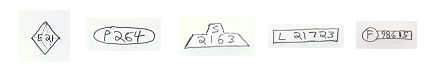
A quick word about the modern world's highway system. The "autoroutes" which you see on the modern map are indeed real highway numbers (ie: A2), but they also have a regional influence, as all the highway numbers in the land are associated with the parent autoroute. The highway classifications parade down like this:
A - Autoroute: One digit. Like the expressway, can be any controlled
access road. Exit numbers by kilometres (like in New Brunswick). Identification
signage unique to each autoroute.
E - Expressway: Two digits. Anything from a two-lane controlled-access
highway to a multi-lane divided controlled-access highway. Usually fairly
short roads that access or bypass parts of a city, though some may also
meander on their own routes. Since there are two digits, the nine main
regions of the autoroutes are further divided into nine more regional expressways,
and it goes on like that down the line. Exit numbers by kilometres. Identification
signage looks like a faceted diamond.
P - Primary: Three digits. May be controlled-access for certain
sections (this mostly occurs in the interior where there aren't any other
roads around). Will have exit numbers only when substituting for a higher-class
road (ie: number ending with zero). Similar to the trunk highways in Nova
Scotia, as uncontrolled-access roads, usually with lines painted on the
sides of the road, with wide lane widths (where possible) akin to the first-class
highways in Prince Edward Island. Identification signage is an oval. In
the interior or the Highlands, the terms 'expressway' and 'primary' roads
are often interchangeable.
S - Secondary: Four digits. Narrower roads, usually without white lines
along the shoulders. Differ from local roads in distance and quality. Almost
always paved. Identification signage is a funky thing that looks kind of
like the provincial secondary road signage in Ontario (though I image those
roads are more like the primary roads in this example).
L - Local: Five digits. Shorter roads servicing small locales. Usually
not as 'fast' as the secondary roads. May be unpaved. Identification signage
is shaped as a rectangle.
F - Frontier: Five digits. There are no additional digits for the frontier
roads due to their general scarcity nowadays and their interchangeability
with local roads. They travel for long distances into the 'back woods'
or mountainous regions, often not really going anyplace. Often unpaved.
Identification signage is a circle followed by a rectangle.
Now to explain the digits situation. Let's say you're traveling on A2 as you drive up into the Highlands, and the road is no longer controlled-access. Then we'd call it P200, where the zeros indicate that the road isn't unique of it's own, unlike a road such as P211 (which, due to the low digits, would be pretty close to the beginning of the highway in Shoreville). Also, you couldn't have a E20 because the expressways are just any big highway that isn't an autoroute.
For another example, let's say that there's an access road to Towerville. By the looks of things, such a road wouldn't begin off of the A2 itself, but rather the E21, which is that long, meandering road along the coastline that ends up going through to the south of Stratford. And such a road probably isn't a primary road, so we'll say it's a secondary road. It's probably also in the area of a P219 highway that I just made up, so we'll call the road S2192. See how this works?
Speaking of highways, do you see that little blue road on the northeast side of Shoreville, south of the Shoreville River? That's the E16, which goes to the International Airport. Just in case you were wondering why that road was there.
Anyway, I realize that at this point you don't have a lot to do besides pour over my maps for a few seconds, but I still think that this was worth doing before I got much further with the novel; this way, I've got some points finalized and ironed out. See you soon.